
Software Development for Mechanized Guiding
Facts
| Project: | Software Development for Mechanized Guiding |
|---|---|
| Place | British Columbia |
| Country | Canada |
| Execution | since 2024 |
| Customer | Mike Wiegele Helicopter Skiing |
| Protected Object | Guides and Guests |
| Installed systems | - WAC.3® Cockpit PRO - WAC.3® Assessment PRO - WAC.3® Runtracker |
Initial Situation
Mike Wiegele Helicopter Skiing (MWHS), founded in 1970 by Mike Wiegele. Operations are based in Blue River, BC, in the heart of the Cariboo and Monashee Mountains, with an additional satallite lodge near Valemount, BC. MWHS tenure contains more than 1.5 million acres and over 1,000 mapped ski runs.
MWHS‘s daily operations have long relied on paper-based recordkeeping, with weather observations, hazard assessments, run information, and other field data captured by hand each day. This approach has served the operation well over its history and reflects decades of accumulated guide knowledge and field experience. As MWHS looks to the future, this way of working presents some challenges: information is harder to review, aggregate, and analyze over time, and passing on institutional knowledge to newer guides.
Rather than pursue a full, immediate digital conversion, MWHS wants to modernize gradually through discrete work packages. The initial focus areas are digitizing AM weather observations, building a run atlas to preserve and transfer generational run-list knowledge, and developing a field-based tool for guides to track runs skied.


Our solution
Development Ethos of Wyssen
In 2020, Wyssen Avalanche Control made a deliberate push to evolve our existing software, WAC.3®, from a platform for operating avalanche towers and monitoring detection systems into a broader operational tool. We recognized that our clients‘ software needs extended well beyond simply sending an ignition code to a tower – their day-to-day operations demanded much more. This realization led to a conscious decision to expand WAC.3® to capture the fuller scope of our clients‘ operational needs.
This development effort was initially directed at our European client base, resulting in new modules within WAC.3® including Accidents (for first aid and incident reporting), Explo Doc (for explosive inventory tracking), Helitrack (for
tracking helicopter-based explosive missions), and Assessment (for documenting hazard assessments and risk treatments).
Recognizing that these modules would eventually need to serve a global clientele – each with different standards, practices, and expectations – our software development team adopted a development philosophy centered on
understanding the underlying mechanics of a client‘s core tasks, rather than building to their specific procedures. This fundamentals-first approach allows a single tool to be applied across a variety of specific use cases. Through ongoing conversations with clients and a deep understanding of how they work, we can adapt and customize our core tools to fit each operation‘s unique needs.
Following a successful rollout across our European clientele, our software development focus shifted to Canada, with new software initiatives launched alongside both existing and new clients – including a major push into the
mechanized guiding industry through partnerships with MWHS.
Solution Mike Wiegele Helicopter Skiing
The morning weather board documentation process was integrated into the WAC.3® Assessment module, combining automated data feeds from MWHS‘s internal automatic weather stations with manual study plot observations into a single form. Once completed, the form‘s data is pushed into two independent PDF reports: a guide-focused report containing the full detail of the original assessment, and a guest-focused report that compiles key data into a more digestible format. Both reports are distributed automatically to separate email lists managed within WAC.3®, and select data fields are pushed directly to the MWHS public website to update guest-facing conditions and forecast information.
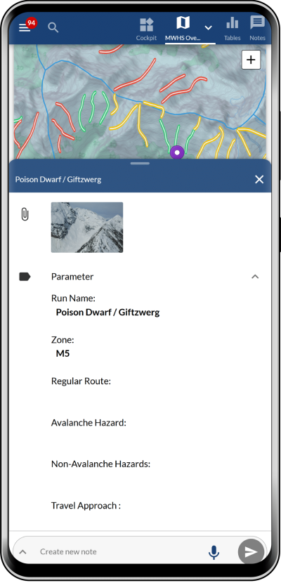
The WAC.3® Cockpit map was configured as a generational knowledge-transfer tool by integrating a run atlas alongside a map layer system that visually displays run status codes based on each morning‘s stability forecast. The run atlas serves as a map-based run catalogue, with each individual run documenting standard considerations such as avalanche hazard, other hazards, approach and travel considerations, and general comments. The run status coding is built from several map layers, each representing a specific stability outcome, visually communicating each run‘s current status through an associated color.
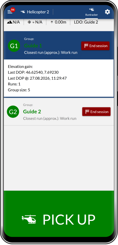
Runtracker was developed as an entirely new module, designed for offline field use. Guides interact with the module through a centralized tablet mounted in each helicopter, with every aircraft operating its own independent instance. The tool allows a lead guide to configure the groups working within their helicopter, while a semi-automated algorithm records and tracks the runs skied by each guide and their respective group throughout the day. At day‘s end, these statistics can be easily compiled and analyzed.
A Project of:
Wyssen Canada Inc.
201A-306 First Street West
P.O. Box 99
Revelstoke BC, V0E 2S0
Canada
Dylan Chen
